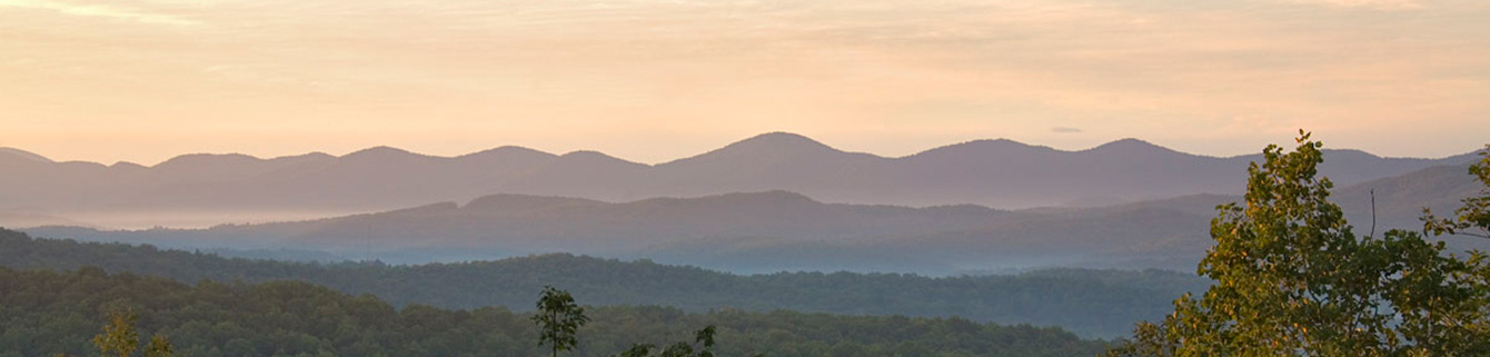
North Georgia Mountain Hiking Trails
The crown jewel of Georgia ~ Blue Ridge's dominant attraction is the myriad of hiking trails that wind through the North Georgia Mountains ~ Over 300 miles of hiking trails in the Blue Ridge area.
Appalachian Trail Begins in Georgia
Finding its roots here close to Blue Ridge GA, the Appalachian Trail begins at Springer Mountain and branches into several accessible hikes in the Blue Ridge area exploring waterfalls, rivers, creeks, stunning mountain vistas, not to mention the beautiful flora and fauna.
Best Hiking Trails in Blue Ridge, GA
Hiking in Blue Ridge offers something for everyone: easy to advanced terrain to experience, forests to hike through, hidden waterfalls to explore, and mountain ranges to marvel at. To add a treasure hunt aspect to your hike, check out geocaching! Pack a comfortable pair of tennis shoes, weather-appropriate clothing, and a water bottle and explore the beauty of the North GA Mountains
Map of Blue Ridge Hiking Trails and Access Points
Find a comprehensive map of the most popular hiking trails in Blue Ridge GA
 Located just under 30 minutes from our luxury Blue Ridge cabins on the Toccoa River you will discover swimming holes, hiking and biking trails, picnic spots, and a 330-foot suspension bridge making the Ocoee Whitewater Center a natural playground!
A legacy of the 1996 Summer Olympics, this site hosted the Canoe, Kayak, and Slalom events and was constructed by the U.S. Forest Service.
Located on …
Located just under 30 minutes from our luxury Blue Ridge cabins on the Toccoa River you will discover swimming holes, hiking and biking trails, picnic spots, and a 330-foot suspension bridge making the Ocoee Whitewater Center a natural playground!
A legacy of the 1996 Summer Olympics, this site hosted the Canoe, Kayak, and Slalom events and was constructed by the U.S. Forest Service.
Located on …
 Discover this 0.8-mile loop trail near Blue Ridge, Georgia, an easy route that takes about 18 minutes to complete. Popular for birding, camping, and hiking, you're likely to encounter other visitors while exploring. The trail is best enjoyed from February through November. Dogs are welcome but must be kept on a leash.
This wooded path offers lovely views of the lake but can be narrow in some area…
Discover this 0.8-mile loop trail near Blue Ridge, Georgia, an easy route that takes about 18 minutes to complete. Popular for birding, camping, and hiking, you're likely to encounter other visitors while exploring. The trail is best enjoyed from February through November. Dogs are welcome but must be kept on a leash.
This wooded path offers lovely views of the lake but can be narrow in some area…
 Brasstown Bald is the highest point in Georgia, reaching an elevation of 4,784 feet above sea level.
It is located in the Chattahoochee-Oconee National Forest near the town of Blairsville, not far from Blue Ridge.
Brasstown Bald is a popular destination for visitors and hikers due to its stunning panoramic views of the surrounding Appalachian Mountains and valleys. You can even see Atlanta, No…
Brasstown Bald is the highest point in Georgia, reaching an elevation of 4,784 feet above sea level.
It is located in the Chattahoochee-Oconee National Forest near the town of Blairsville, not far from Blue Ridge.
Brasstown Bald is a popular destination for visitors and hikers due to its stunning panoramic views of the surrounding Appalachian Mountains and valleys. You can even see Atlanta, No…
 Bell Mountain is a popular hiking destination located near Hiawassee, Georgia. Offering 360-degree views of the surrounding mountain ranges and Lake Chatuge, Bell Mountain is a favorite spot for hikers and nature enthusiasts.
From the parking lot, climb up the easily accessible rocky trails to the top of the summit and breathe in the fresh mountain air. The other side of the parking lot offers a …
Bell Mountain is a popular hiking destination located near Hiawassee, Georgia. Offering 360-degree views of the surrounding mountain ranges and Lake Chatuge, Bell Mountain is a favorite spot for hikers and nature enthusiasts.
From the parking lot, climb up the easily accessible rocky trails to the top of the summit and breathe in the fresh mountain air. The other side of the parking lot offers a …
 Springer Mountain, located in the scenic Blue Ridge Mountains of Fannin County Georgia, is a must-visit destination for hiking enthusiasts.
As the southern terminus of the iconic Appalachian Trail, Springer Mountain offers a rewarding hiking experience with stunning panoramic views, lush forests, and diverse wildlife.
The hike to the summit is accessible via the Springer Mountain Trail or the Ap…
Springer Mountain, located in the scenic Blue Ridge Mountains of Fannin County Georgia, is a must-visit destination for hiking enthusiasts.
As the southern terminus of the iconic Appalachian Trail, Springer Mountain offers a rewarding hiking experience with stunning panoramic views, lush forests, and diverse wildlife.
The hike to the summit is accessible via the Springer Mountain Trail or the Ap…
 Located near Blairsville, GA, Vogel State Park is one of the oldest state parks in Georgia. Located at 2,500 feet above sea level, Vogel sits at the base of Blood Mountain, the highest summit on the Appalachian Trail in Georgia, surrounded by the Chattahoochee National Forest. Aside from hiking, other activities at this park include fishing, geocaching, mini golf, swimming, and kayaking.
Best Ti…
Located near Blairsville, GA, Vogel State Park is one of the oldest state parks in Georgia. Located at 2,500 feet above sea level, Vogel sits at the base of Blood Mountain, the highest summit on the Appalachian Trail in Georgia, surrounded by the Chattahoochee National Forest. Aside from hiking, other activities at this park include fishing, geocaching, mini golf, swimming, and kayaking.
Best Ti…
 The Swinging Bridge on the Toccoa River is a very popular destination for day hikers. Located on the Benton MacKaye Trail, this 265-foot-long bridge is the longest swinging bridge east of the Mississippi River.
In 1976 the Forest Service, along with the Georgia Appalachian Trail Club, replaced a dangerous ford of the Toccoa River in this area. A private contractor built the bridge, which was comp…
The Swinging Bridge on the Toccoa River is a very popular destination for day hikers. Located on the Benton MacKaye Trail, this 265-foot-long bridge is the longest swinging bridge east of the Mississippi River.
In 1976 the Forest Service, along with the Georgia Appalachian Trail Club, replaced a dangerous ford of the Toccoa River in this area. A private contractor built the bridge, which was comp…
 The name "penitentiary" may make you wonder about taking this hike, which completes a circuit on the east side of the Cohutta Wilderness. The total distance of this Loop is 13.1 miles, meaning that the hiking time is about 6 hours and not for the faint of heart.
The history and story goes like this: When the Jacks River basin was being logged in the 1930s, the Great Depression was on.
At the tim…
The name "penitentiary" may make you wonder about taking this hike, which completes a circuit on the east side of the Cohutta Wilderness. The total distance of this Loop is 13.1 miles, meaning that the hiking time is about 6 hours and not for the faint of heart.
The history and story goes like this: When the Jacks River basin was being logged in the 1930s, the Great Depression was on.
At the tim…
 This reasonable loop starts at Lake Winfield Scott, a great swimming and fishing destination, and explores sheltered mountain valleys divided by an Appalachian Trail ridge walk.
It heads up Slaughter Creek, crossing streams on a moderate grade to meet a rerouted section of the Appalachian Trail. It then travels atop a lightly wooded ridge line on the world's longest marked footpath to reach Jarra…
This reasonable loop starts at Lake Winfield Scott, a great swimming and fishing destination, and explores sheltered mountain valleys divided by an Appalachian Trail ridge walk.
It heads up Slaughter Creek, crossing streams on a moderate grade to meet a rerouted section of the Appalachian Trail. It then travels atop a lightly wooded ridge line on the world's longest marked footpath to reach Jarra…
 With more than 40,000 acres in Georgia and Tennessee (known as Big Frog Wilderness Area), the Cohutta Wilderness comprise the largest wilderness east of the Mississippi. The Cohutta Mountains are part of the oldest known mountains in the world. They run from Fannin County northeast to the Tennessee-North Carolina border, where they are known as the Smoky Mountains. It is from these mountains that …
Pages